Mt. Kalugong

MT. KALUGONG ECO PARK


Updated article is migrated on this link:


Location: La Trinidad, Benguet, Philippines
Google Map:


Coordinates: 16°27'37"N 120°35'44"E.
Major Jump-Off Areas: Cruz, La Trinidad, Benguet
Contact Details: 09196728888 or 09498980328
Entrance Fee: Php50.00
How to Get There: From Baguio City, take a jeepney bound to Tomay, Acop or Shilan. Drop at Benguet Memorial Services in Brgy. Cruz. The trail starts at the cemented road at the right side of this establishment.

Description
Of the mountains surrounding the salad bowl of the Philippines, Mt. Kalugong might be the most popular. There are three alluring reasons why this mountain is becoming more widely known. One, it offers a panoramic view of the whole valley and the pastureland and pine forests at the western portion of the municipality. Notable establishments seen from the mountain includes the whole stretch of Benguet State University, Benguet capitol building, La Trinidad municipal hall, strawberry fields, Bureau of Fisheries and Aquatic Resources fish ponds, and the Balili River snaking along three-kilometre stretch. Two, Mt. Kalugong offers a quiet place to relieve the stresses of the urban life. Currently, there are native huts, benches and tables, swing, and two ziplines erected in the conifer-covered area of the mountain. This environment is very pleasant to family or group picnics. Three, for the adventurous persons, Mt. Kalugong offers boulders upon boulders of limestones of different sizes and shapes.

The name of Mt. Kalugong came from a local word which means “hat”. This name is coined from a stone boulder resembling a baseball hat at the southern portion of the mountain as seen from the eastern part of the valley. Before the place was developed as an ecological park, the rock formations had been drawing a lot of locals. The area where it is not covered with limestone was previously used as venue for 4x4 off-road car racing.

Reminders
·         The Tabangaoen trail is already closed since 2014.
·         Practice the Leave-No-Trace (LNT) principle when visiting the place.
·         Do not vandalize the stone formations.

Gallery
The limestone formations have always been the biggest asset of the place.


Plants growing at the crevices near the ground.


At the top of the mountain, the panoramic view of the valley can be seen. However, in order to see this you need to move further west.


Buburtak weeds are all over the place. With that being said, bees are also present during the blossoming season.


If you are afraid of heights, this is not your place. Wear clothes suited for climbing rocks upon rocks.


Mt. Jumbo can be seen towards the southeast horizon.


Its as if the rocks were strategically planted on the ground.


Note the size of the rock to the brush.


Don't wander on the limestone area at the heat of the day. It will be hard finding a shaded area.


Lichens cover some surfaces of the stones. Be wary of them to avoid slipping.


Mushrooms growing in a piece of wood wedged between stones.


This part reminds me of NatGeo shows. Its a perfect combination of rocks and greens.


Spot the dragon.


Mt. Pulag

MT. PULAG


Updated article is migrated on this link:


Location: Parts of it are located in Benguet, Ifugao, and Nueva Vizcaya, Philippines.
Google Map:
Coordinates: 16°34'58"N 120°53'15"E.
Major Jump-Off Areas: Babadak Ranger Station, Bokod, Benguet (Ambangeg Trail), Brgy. Doacan, Kabayan, Benguet (Akiki Trail), Sitio Labang, Brgy. Tawangan, Kabayan (Tawangan Trail).
Trails: Ambangeg Trail, Akiki Trail, Vizcaya Trail, and Tawangan Trail.
Contact Person: Emerita Albas (DENR-PASU): 09196315402.
Registration Fee: Php225.00 (For updated fees, contact Ms. Albas).

Description
At 2,922 meters above sea level, Mt. Pulag is the highest peak in Luzon (UNESCO, 2006). Its fame is attributed to the scenic view at the peak especially during sunrise and sunset. The heaven-like scene at the summit, the “sea-of-clouds” phenomenon, and the unobstructed view of the Milky Way at dawn are but some reasons why mountain climbers kept on coming back in this “playground of the Ibaloi gods”. During sunrise, the changing of colors in the horizon and the mountainsides turning into gold when kissed by the early morning sun are breath taking. In order to protect and preserve the outstanding natural features particularly the wildlife, vegetation and the tarns of the area, Mt. Pulag was proclaimed National Park by virtue of Pres. Proclamation No. 75 on February 20, 1987 covering an area of 11,550 hectares (Pres. Proclamation No. 75 s. 1987). The preservation of Mt. Pulag also greatly reflects the cultural values of the locals. The lakes and mountains, like Mount Pulag, are deemed sacred and home of the spirits of their ancestors; thus, protected and kept safe.

There are three types of vegetation in the area suggesting the transition of elevations. The summit is covered with grass and the dwarf bamboo (Yushania niitakayamensis). At lower elevation, the mossy forest covers the mountainside. Below the small tree, fern, lichen, moss, and fog-covered mountainside is the coniferous forest. Mt. Pulag is also home to the Philippine Brown Deer, cloud rat (Crateromys schadenbergi) and the Luzon pygmy fruit bat (Otopteropus cartilagonodus).

Braving to camp at the summit during December, January and February exposes climbers to freezing temperatures and sometimes accompanied with rainfall. Planning ahead of time and considering the season of the year would prepare climbers from undue situations.

Respect and Protect
Respect the people and their culture. The beauty of Mt. Pulag has persevered until today mainly because of the belief and tradition of the locals surrounding it. Paying the meager registration, tour guide, and porter fee does not mean that you own them and the land. Give due respect to the locals, their culture and to the mountain.

Protect the environment. The influx of weekend and holiday tourists has a drastic impact on the mountain. For one, a lot of footpaths have been created in spite of the pre-climb orientation that only one path should be followed. Always practice the LNT principle when mountain climbing or camping. You can freely take pictures but don’t take any plant, stone or moss.

Gallery

Sunset at the campsite. Unfortunately, the foggy afternoon blocked our view of the colourful sunset. During rainy season, this also becomes a problem during sunrise when the sun is covered with heavy fog and rain clouds.


During the dawn, the dark silhouette of the mountains adds to the beauty of the imminent sunrise. This is a common scene halfway to the summit.


The colors of the horizon will take your breath away. All you can do is widely open your eyes… and often your mouth, too.


The colourful sunrise and the sea of clouds will always be a treat to the early birds at the summit. You need to wake up and start the ascent to the summit as early as 4:00AM if you want to see this.


The sea of clouds sometimes become like a fast flowing river. Every minute, the wind changes the cloud scene.


The face of the mountains turns gold as it is kissed by the early morning sun.


Here comes the sun!


 You can witness mountain tops upon mountain tops touched by the rays of the sun.


The clusters of dwarf bamboos (Yushania niitakayamensis) at the summit grow as high as three to four feet.


During December to January, the dwarf bamboos are often moist from the fog. And they are haven for the ill-clothed climbers when the fog and chilly wind blows.


The rolling hills with the sea of clouds as background. When you thought you had your fill, more breath taking views are yet to be seen.

As the sun goes higher, the color of the grass-laden mountains turns to green.


The fog plays like a playful carpet. But this adds to the beauty of the moment making the mountaintops and hills like an elusive lady.


And just when a clear blue sky is needed, the fog and clouds obediently withdrew.


The sun warms the chilly atmosphere. Take note, however, that you are at high risk of sunburn without proper sun protection at this time and onwards.


It is not uncommon that you will just sit on the ground and be mesmerized by the wonder of God’s creation.


And yes, they’re grasses. And they’re beautiful.


It really must be the playground of the gods!


Even the trees are beautiful to behold.


REFERENCE LIST:
Pres. Proclamation No. 75 (February 20, 1987). Retrieved on April 09, 2015 from http://www.gov.ph/1987/02/20/proclamation-no-75-s-1987/.
UNESCO (2006). Mt. Pulag National Park. Retrieved on April 09, 2015 from http://whc.unesco.org/en/tentativelists/5030/.


Bahay na Bato

BAHAY NA BATO


Updated article is migrated on this link:


Location: Nalvo Norte, Luna, La Union, Philippines
Coordinates: 16°50'51.3"N   120°21'01.6"E

Jump-Off Area: Municipal Hall, Luna, La Union
Contact Person: Tito Gorospe (Tourism Officer): 09158072728 (Mobile No.) OR (072) 607 0099 / 607 1132 (Landline)
Entrance Fee: Php20.00/pax
How to Get There:
  •  From Manila or Baguio City, take a bus bound to Laoag, Vigan or Abra. Drop at Balaoan, La Union. Take a tricycle near the Seven-Eleven Store to Luna town proper. Take another tricycle to Bahay na Bato.
  • From San Fernando City, La Union, you can take a Luna-bound jeepney. Otherwise, follow the travel plan for those coming from Manila or Baguio City.

Description:
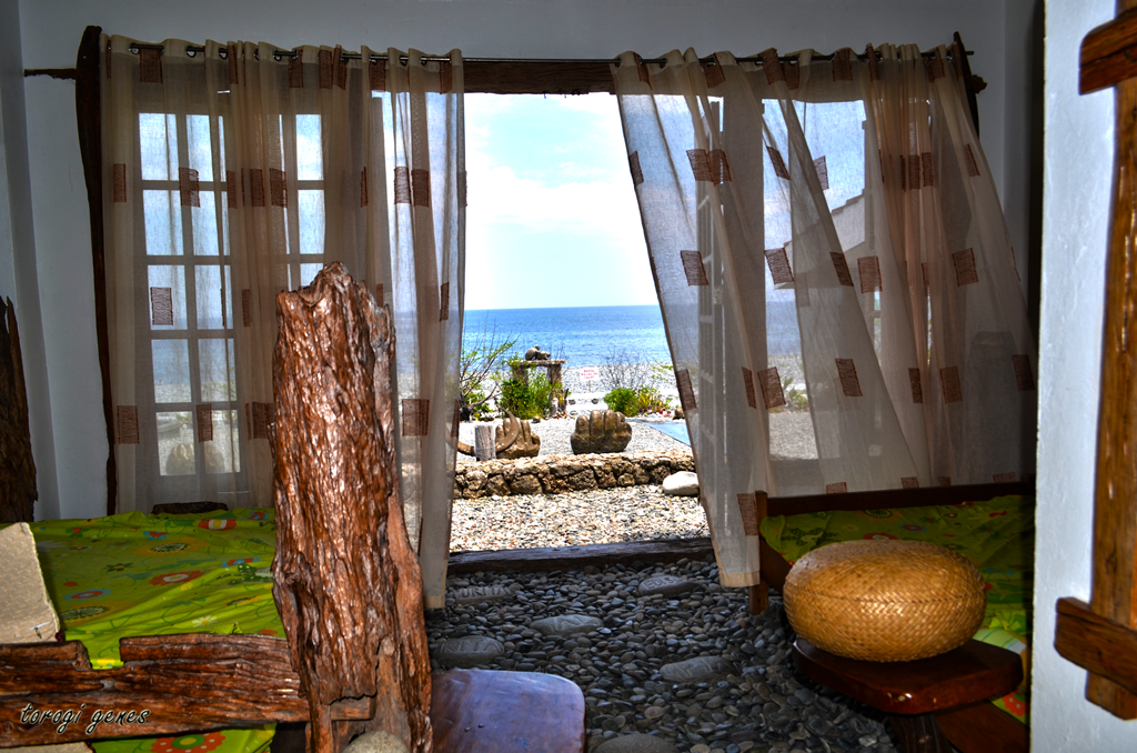
Bahay na Bato (stone house) is situated in a 35,000-populated municipality of Luna (Philippine Statistics Authority, 2010). In reality, it is not a house made entirely from stones, although the concrete walls are plastered with stones and the floor is strewn with large, smooth, flat pebbles. Adornments of carved stones, woods and World War II items are seen inside the house. Of the two private rooms in the ground floor, the one facing the beach is sometimes open to the public. This room has a double-door access to the beach. Carved stones of different sizes and figures are strategically positioned along the hallways. The floor is also covered with smooth, pebbles and flat quarter-palm sized stones. Woods carved with faces are also mounted on the upper portion of the inner wall of the receiving hall. World War II items such as charcoal iron (de uling na plantsa), kerosene lamps (lampara), water canteens (kantina), carbide lamps (de kalburong lampara), wooden trunks (baul), and Stainless Steel mess kit dishes are also being showcased in the house.  The second floor offers a panoramic view of the pebble-blanketed beach and stone carving-strewn lawn. Big stone carvings resembling lizard, heart, sea creatures, flowers, man, hand gestures, etc. are positioned to augment or create a landscape. Though there is a minipool for children on the southern part of the house, the main attraction is still the house and its stone carvings.

The house, built in 2000, was initially intended to be a resthouse for Dr. Edison and Dra. Purita Noble; however, Luna Mayor Marvin Marron, seeing the tourism potential of the property, persuaded them to open it to the public (Marbella, 2015). The property was then opened in 2014 attracting a multitude of tourists. The local tourism office has recorded a staggering number of visitors to the new attraction. In December 2014, it registered more than 10,000 visitors, and another 7,800 for January 2015 (Marbella, 2015). 

If you visit this place, you have a big chance of meeting the sculptor of the stone-carvings, Mr. Vong Kim. He is a Korean married to the Luna native manager of the place. He usually stays at the registration booth. 

Other notable tourist attraction of this municipality is the pebble-covered beaches, even coming in different colors. According to a resident near the beach, the pebbles are believed to be living and has the ability to grow. Baluarte ruin (Biyak na Bato) and Ukkalong Falls are also gaining popularity in the place.

GALLERY:

    
Here's the admission fee and open house hours as of February 2016.

The receiving hall’s floor is covered with large flat pebbles.


The receiving hall window overlooking the beach.


The upper portion of the walls is also lined with woods carved with faces.


The hallway leading to the two private rooms and the stairs.


One of the private rooms. This rooms is sometimes opened to the public.


The eastern wall at the second floor is adorned with World War II utensils.


 Close up of the WWII utensils.


A wooden trunk as a centerpiece at the second floor.


Stone carvings in the ground as seen from the second floor window.


 Stone and wood carving in a hallway.


This carving obviously depicts the Oriental culture of the carver. 


Stone-faced? Call what you want. 


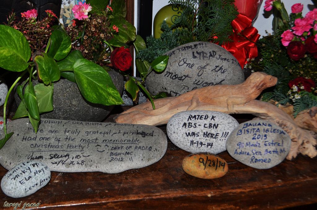
Your name might be in this table too. 


I actually wondered how they did this.


Emotions etched upon stones. 


Yes, its not slimy. Its smooth. 


Homo erectus(?) with glasses. 


One of the best places outside the house. Don't just linger in the middle of the heat.


 A monster fish, perhaps.


The beach without sand.


Unfortunately, swimming is not allowed  at the beach near Bahay na Bato. The waves are strong and the beach is deep.


Pebbles and not sand. How is sunbathing done here? 


 Pebbles of different colors can be picked near the Baluarte ruins.


According to the locals,during the war, this structure is connected to a nearby building through a tunnel, making it a means of escape. 


But I love the view! 


The Baluarte ruins as seen from the beach. Concrete posts are used to fortify the structure preventing it from collapsing. This structure is becoming an icon of Luna. 


Accordingly, the structure has split during a previous typhoon. 


REFERENCE LIST:
Marbella, J. P. (2015). Stones bring solid tourism in La Union. Retrieved on April 2, 2015 from http://www.launion.gov.ph/news.php?extend.687.1.
Philippine Statistics Authority (2010). 2010 Census of population and housing. Retrieved on April 2, 2015 from http://web0.psa.gov.ph/sites/default/files/attachments/hsd/pressrelease/Ilocos.pdf.